As part of the weekend's mountaineering we are out again with Guide Brian Morrison to practise rope work in exposed terrain. Today's plan was supposed to be Ledge Route on the North Face of Ben Nevis, however with the current dangerous snow conditions the route was inaccessable so myself, Ian, Carl, and Brian headed to a low level winter climb. The Zig Zags on Gearr Aonach, the middle shoulder onto Stob Coire Nan Lochan, also known as the middle of the three sisters of Glencoe.
The middle sister looms up ahead. 2200ft of rock and no visible way up!
Everyone is geared up and ready to make our way up.
Glencoe is snowed right down to the ground.
The way up the rock face is ahead. Taking very careful steps up the path to the Lost Valley as the drop to the gorge below is very real and close when their is ice everywhere.
The route up follows a series of narrow ledges which zig zag (hence the name) up the rock face. They are pretty exposed. Make our way to the pitch and come across a slab of rock with a fine dusting of snow. My crampons would not get purchase anywhere. I manage to take my mitt off and get a good hand hold to get to the top. If you look at the top right that is the main Glencoe road down in the distance where we came from.
Ian sets up the anchor for the pitch so we can safely move up this section of rock and ice.
Carl leads the pitch up.
Ian belaying.
A few tricky moves to get up here trying to get a good purchase on the ice and ground with the axe.
Looking down into the Lost Valley after the pitch.
We then follow the ledges up and eventually come to the summit. The road snaking through Glencoe can be seen below.
The Aonach Eagach behind me.
Carl with Aonach Dubh behind him.
Over towards the Devil's Staircase.
Spot of tea my good sir?
Heading across the summit snow slopes towards Stob Coire Nan Lochan.
Aonach Eagach.
Moving to the bottom of Stob Coire Nan Lochan and Dorsal Arete which are plastered in snow. There are large amounts of avalanche debris sitting at the bottom of the main gully.
On locating a small snow field on the NW aspect, a small snow pit shows the clear surface hoar layer which is responsible for all the avalanches over the last week. The block broke away easily. This is very unstable snow.
Heading down Coire Nan Lochan back towards the car.
The Aonach Eagach is lighting up in sun now.
On heading back down the Coire we pass by small gullies which have had lots of avalanche debris funnelled through them recently. We cross these small patches quickly.
Stob Coire Nan Lochan up in the distance. Dorsal Arete in winter is on my "to do" list. Need to get back up here as soon as the snow stabilises some more.
Trudging through the snow back to the car.
Sunday, 28 February 2010
Saturday, 20 February 2010
Arran - Goatfell - 20-02-2010
With this recent spell of blue skies I knew I wanted to get out this weekend and today was the only day I could get out but with the Scotrail stikes the west highland railway was not running so I had a think of different options and Goatfell on Arran was my decision.
Left the house at half seven and got the train to Glasgow and then another train straight to Ardrossan Harbour, and on the Ferry across to Arran.
It was a bit of a misty start to the day so the view across to Arran was a little obscured with only the tops of the mountains poking out the top.
Leaving the mainland behind in the same mist. Feels like open sea.
Beautiful blue skies and clear waters make for a pleasent sailing across.
Getting closer and Goatfell can be seen poking out the mist.
Arriving in Brodick.
On landing at port a bus was sitting waiting, and five minutes later I was dropped off at Cladach near Brodick Castle, which is the start of the trail.
A little great tit.
The way to Goatfell is clearly signposted through the plantations.
Where I am going comes into view going through the forrest.
Leaving the bay behind.
Getting closer.
The sky has started to fill up with some clouds and obscuring the summit. There is very little wind and the clouds are moving slowly so I hope they clear off by the time I get there.
Above the snow line now the only sign of a path is footprints in the snow, which is fresh and powdery so I follow on in the stead. The ridge to the summit is visible.
Brodick bay below the snow line.
The slope is steep and very slippery, but I make the decision not to put on my crampons and rely on step kicking and my ice axe to get me up and while making my way up the slope the peace was disturbed by a group of guys coming down in jeans and wellies and I wonder how they managed to get up.
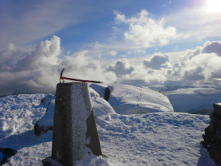
At the top and the sky has pockets of cloud everywhere spoiling the views to Ireland and the Islands.
The bay far below.
The view point table. Not much use though.
Looking down to the bealach known as "the saddle" between North Goatfell and the neighbouring corbett Cir Mhor.
Over to the mainland.
Dont fall!
Peaceful waters.
Across to Beinn Tarsuinn, another fine Corbett which I plan on coming back to climb.
A fine ridge between Cir Mhor and Beinn Tarsuinn.
Across North Goatfell to its most northely top. I dont have a lot of time today to catch the ferry back so the tops will stay for another day.
Down the Coire-Lan which ends at the village called Corrie.
Leaving the summit behind.
Heading back down the harbour.
Sunset from the top deck of the ferry.
A well deserved beer.
A fine day outside the highlands and further proof that there is more to the hills than the Munros, and that the obsessive baggers are missing out on good days out.
Subscribe to:
Posts (Atom)